Last week I sent a fairly random Tweet about deforestation in south-eastern Queensland being partially responsible for the record floods there. It went more or less unnoticed, but I thought the comment deserved a proper explanation.
As many of you might know, my colleagues and I wrote an article a few years ago about the global-scale evidence for deforestation leading to a higher incidence and severity of floods in the developing world. This was fairly controversial, but it was nonetheless the first broad-scale evidence for the fabled deforestation-flood link yet published (in my not-so-humble opinion). Subsequent comment reiterated the point with new data.
Now, I will begin by saying I have no data yet to back up my Queensland-specific hypothesis, but I am contemplating a time-series paper on floods in Australia, especially after the events of the last month. This post is therefore merely a reasoned hypothesis.
The hypothesis itself is rather simple. Testing is not. I submit that the recent flooding in Australia has been exacerbated (not caused) by the rapid loss of forest cover over the last 40 years. We know that this is a particularly intense La Niña in Australia and our unusually high rainfall arises from this meteorological phenomenon, but I hypothesise that it wouldn’t have been as bad if this part of Australia hadn’t been so careless with its forest cover since the 1970s.
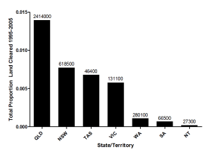
So what’s the evidence? Well, Queensland, especially south-eastern Queensland, has had some of the highest rates of forest loss since the 1970s. I trawled various government databases (data sourced from here and here) and discerned that not only did Queensland have the highest total forest loss between 1995 and 2005, it also had the highest proportional (i.e., relative to its area) forest loss since that time (Fig. 1).
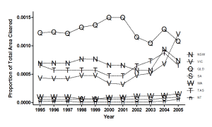
Interestingly, this trend in proportional loss was maintained over the period 1995-2005 – Queensland had the sustained highest proportional (and absolute) rate of loss (Fig. 2).
Sure, most of you are familiar with the sad case of government-promoted land clearing in south-western Australia’s during the 1950s in the so-called ‘wheat belt’ which eventually gave rise to the dubious distinction of inclusion in the world’s Biodiversity Hotspots. Southern South Australia lost a good deal of its forest cover earlier, and New South Wales and Victoria have had a pretty poor history too (see David Lindenmayer‘s excellent book On Borrowed Time for the gory details). Nonetheless, it’s Queensland, and particularly the south-eastern section, which has copped the brunt of this cumulative wave of forest loss in our most recent history.
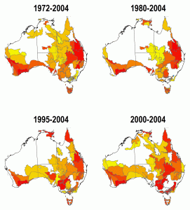
To support this contention, I pulled up the forest loss data for the Interim Biogeographic Regionalisation of Australia (IBRA) bioregions and mapped the net-loss regions from 1972-2004, 1980-2004, 1995-2004 and 2000-2004 (Fig. 3: increasing redness = increasing forest loss). As you can see, south-eastern Queensland (and some of northern New South Wales) has really been the epicentre of forest loss since the early 1970s (you can also so the legacy of loss in south-western Western Australia too in the earlier years – Fig. 3).
So I contend that the rapid deforestation and degradation of Queensland’s forests over the last few decades has destabilised the soil moisture regime to a point where it can no longer handle extreme weather events. This isn’t to say for a moment that these floods wouldn’t have happened if Queensland still retained all her forests – I hypothesise simply that they wouldn’t have been as severe.
Now, it will take some time and a good flood database (both spatial and temporal – the world’s only really flooding database can be found here) to test this hypothesis. But given our previous results, the catastrophic floods hitting some extremely (and recently) deforested places in the world like the Atlantic coast of Brazil, Sri Lanka, the Philippines, and Pakistan, I think we’re starting to see a trend. Sure, climate change will probably make all these catastrophes more commonplace anyway, but we sure aren’t helping ourselves by cutting down our only real natural buffers.
I must finish too by stating that in 2004, the Queensland State Parliament passed an historic piece of legislation vastly limiting land clearing there. A great move, and reforestation projects are happening all over the state. However, much of the damage has already been done. Let’s hope we don’t do much more.


[…] ConservationBytes. 2011. “Deforestation Partly to Blame for Queensland Floods.” Accessed May 28 2015. https://conservationbytes.com/2011/01/17/deforestation-qld-floods/. […]
LikeLike
The Australia-wide deforestation statistics are now published here.
LikeLike
Download paper at:
Click to access AURISA2000.pdf
LikeLike
Hi there there’s an interesting paper on fragmentation of vegetation from 1974 -1997 in the Lockyer valley which indicates why they had such an extreme event. Add pre 1974 clearing and post 1997 clearing and you have a system with a very different hydrological response
LikeLike
Thanks, Doug. That looks really helpful. I’ll follow this up for sure.
LikeLike
[…] Queensland has had the highest deforestation rates among the states in the latter half of the 20th Century […]
LikeLike
[…] me. But I definitly did know about alot of the environmental issues going on there – like the flooding in brisbane due to deforestation, the cane toad infestation (every single one of you should watch […]
LikeLike
Corey, I’m always fascinated how assiduously you can follow the causal chain but stop before
reaching anybody’s plate :). People don’t cut down forests and woodlands for fun.
They do it so that people who enjoy BBQs can use meat instead of veggie burgers. Or so they can export the meat to Japan and the US who will tut-tut about our deforestation over a steak. “Those damned silly QLD red (chomp) necks (chomp) cutting down their (chomp) forests and exacerbating their floods!” … the buck stops with the consumer.
LikeLike
You might also consider replacing (adding) your (chomps) with the sounds of mangos, bananas, bread (wheat) and rice being ingested.
LikeLike
And I’m always ‘fascinated’ how you manage to bring every single issue in the world back to cows.
LikeLike
“… the buck stops with the consumer.”
Well, yes, assuming that consumers are rational and not influenced by advertising or CSIRO total well-being diet books.
LikeLike
Of course! We’ve disrupted the natural water cycle by deforesting and urbanising river catchments, so we can’t expect anything less. Floodplains hold an integral role in the Australian environment–disregarding their function simply creates problems for us.
http://manuelinor.wordpress.com/2011/01/16/water-damage/
LikeLike
[…] This post was mentioned on Twitter by Patrick and ConservationBytes. ConservationBytes said: Deforestation partly to blame for Queensland floods: © recoverling Last week I sent a fairly random Tweet about … http://bit.ly/gLFbq5 […]
LikeLike
Couldn’t agree more. How about, if we spent some money on assuring that all catchments, from creeks to rivers, have a corridor of vegetation surrounding them. We will decrease overland flow, and increase infiltration. I’m just talking about a 20 m buffer zone or something similar. There are a million other benefits to doing this and I believe the money would be better spent then on building a more dams (Abbots solution).
LikeLike
Good idea, but I don’t think this would be enough. Catchment-scale forest cover is needed to attenuate peak flows.
LikeLike
If you do such a paper, you might also want to consider the impact of considerably historically high levels of overgrazing in WA’s Gascoyne-Murchison region, and any linkages to the recent flooding in Carnarvon…
LikeLike
Yes, thanks – I’d probably do all of Australia simultaneously.
LikeLike