Little is known of the true scale of the epidemic, and historians have sometimes argued it was not caused by the newcomers.
In new research published in Nature Human Behaviour, we used modelling of smallpox transmission and the connections between Indigenous societies to understand how it could have spread.
The results strongly suggest the disease did come from the British outpost. What’s more, it might have spread thousands of kilometres north and west, lasting decades and killing as many as 220,000 Aboriginal people.
A destructive force throughout history
Infectious disease has long been one of history’s most destructive forces. The COVID pandemic, which killed an estimated 15 million people in 2020–2021, is only the most recent entry in a list including the Black Death, which killed up to half of Europe’s population in the 14th century, and the “Spanish” influenza of 1918 that was responsible for some 17 million deaths.
One of the earliest recorded – and most feared – diseases was the now-eradicated smallpox, caused by the variola virus.
Evidence of smallpox has been identified in Egyptian mummies dating to as early as 1500 BCE. In 18th century Europe, an average 400,000 people died every year from smallpox. An estimated 300 million people died of the disease during the 20th century, about double the total deaths from wars fought during the same period.
For Indigenous peoples around the world, smallpox was one of the most devastating diseases introduced by Europeans. The disease was a major driver of the catastrophe that killed countless Native Americans from Canada to Tierra del Fuego after the arrival of Spanish and Portuguese in the 16th century.
Smallpox caused fever, severe illness, and high death rates, especially in Indigenous populations with no previous exposure. Survivors were left with severe scarring.
What caused the 1789 smallpox epidemic?
A persistent narrative in Australia’s colonial history is that the disease did not come from the First Fleet. Instead, the argument goes, it was introduced earlier by Makassan traders in the far north of the country. Supporters of this idea proposed that it just happened to make its way to Sydney by the time the British established a colony there.
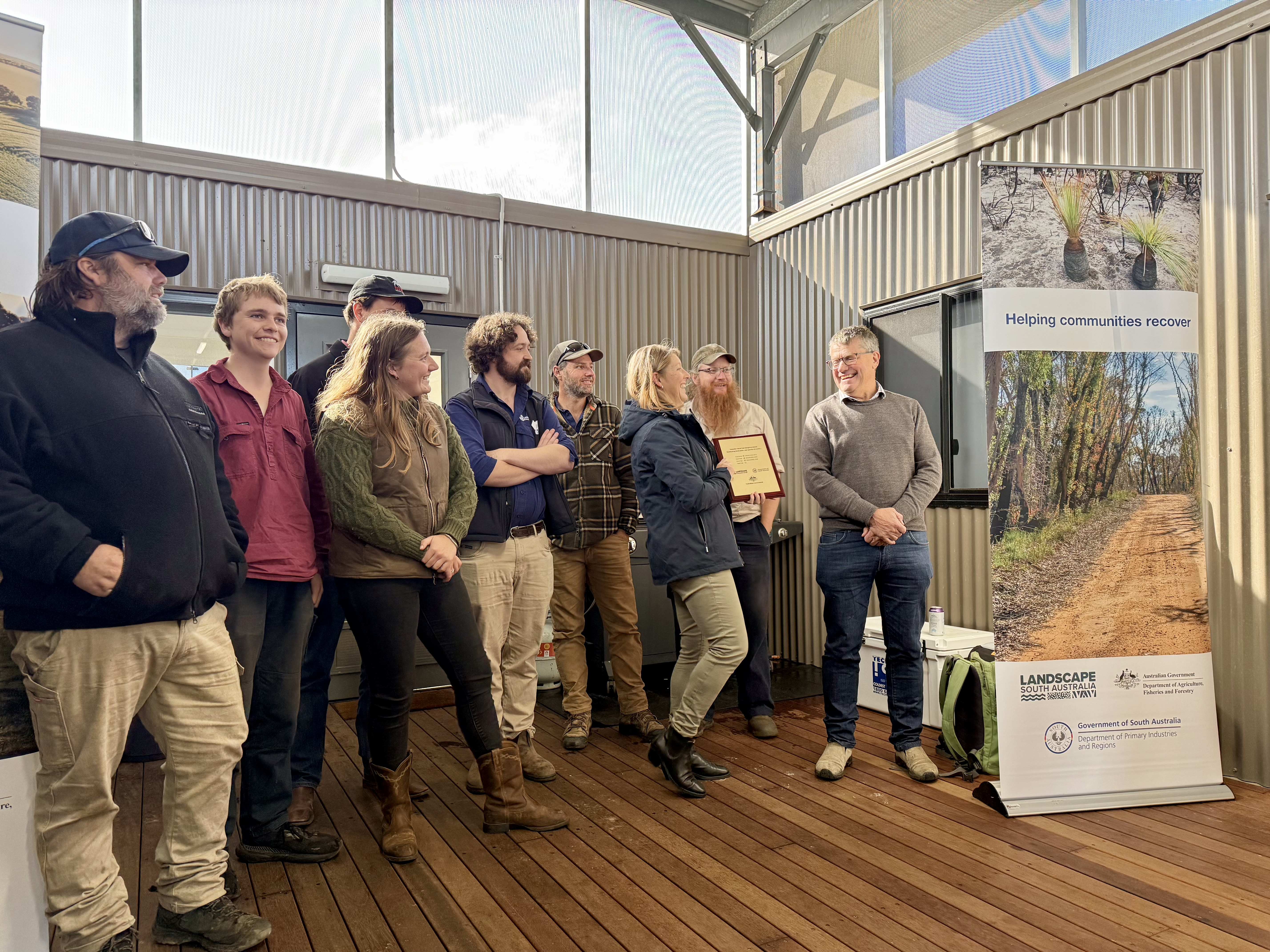
Just over two years ago I reported the ‘likely’ eradication of feral pigs from Australia’s third-largest (4,405 km2) island — Kangaroo Island. I indicated ‘likely’ because the program still required the proof-of-eradication phase to be completed before an official declaration could be made.
Yesterday I had the immense honour to take part in the official declaration ceremony held on Kangaroo Island near Karatta in the island’s southwest.
I can’t begin to emphasise enough how monumental this outcome is for biodiversity conservation, not just for South Australia, or even Australia, but globally.
This is without a doubt the largest island eradication of pigs anywhere in the world. Considering that most eradication (or even density-reduction) programs fail, the success is even more outstanding.
I am also taking some personal pride in the outcome because I had a small part to play. One dreary Sunday morning back in 2022, the head of PIRSA’s Invasive Species Unit Dr Brad Page rang me with an urgent request. “Corey”, he said without much preamble, “I need a model to tell me how much it would cost to get rid of pigs on Kangaroo Island, and I need it by this afternoon”.
Have you ever done any research that relied to any degree on Indigenous Knowledges? How did you cite those Knowledges, if at all?
It’s probably time we rethink how we engage with Indigenous Knowledge systems.
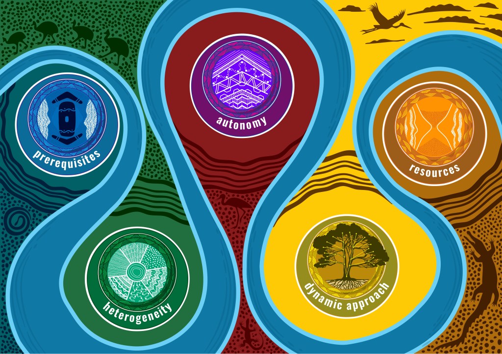
In a new article published in BioScience, we — a large group of Indigenous and non-Indigenous scholars in Australia — call for a fundamental shift in how universities and scientists publish research that draws on Indigenous Knowledges (proper noun; the sum of the understandings, skills, and philosophies developed by Indigenous societies with long histories of interaction with and custodianship of their natural surroundings).
Therein we warn that current academic practices risk sidelining First Nations authority while benefiting from their expertise.
Infographic summarizing the main considerations for crediting and citing Indigenous Knowledges. prerequisites: traditional shield and two boomerangs to represent cultural and legal authority, and framing it with two faces to represent face-to-face conversations; heterogeneity: diversity of First Nations peoples with different patterned backgrounds; autonomy: arrow pointing upward represents First Nations peoples in decision-making position; dynamic approach: decision tree representing formal procedures (also see figure 2 ); fig tree representing staying grounded and being connected to Country; resources : hourglass represent time, also framed by faces. Commissioned original artwork by Tarquin Singleton, Yirrganydji Creative, Red Ochre Republic.
Without question, Indigenous groups must be treated as active partners in research publications — not just contributors acknowledged in footnotes or ‘personal communications’.
Governments, funding bodies, and other institutions increasingly emphasise Indigenous engagement, yet publication practices have failed to keep pace, leaving communities without real control over how their Knowledges are used, cited, or shared.
A few weeks ago we published a paper that was in the works for a long time, so long in fact that one of my co-authors died before it was published online.
Paul Ehrlich died on 13 March 2026 at the ripe old age of 93, exactly two weeks before our article appeared online. Paul had a good innings no doubt, but I wish he had survived long enough to see what might very well be his last co-authored paper.
I first met Paul back in the mid-2000s during a trip through San Francisco. I had organised to come chat with Professor Gretchen Daily at Stanford, and Paul came along for lunch. I remember vividly how we clicked almost immediately.
We clicked so well in fact, that we wrote a book together, co-authored several high-impact papers (e.g., ‘ghastly future‘), spent a month in Bellagio as Rockefeller Foundation writing residents, participated in various public and parliamentary presentations, and generally just got on like a house on fire. Paul and his wife Ann became like family, so much so that they were de facto grandparents to my daughter who grew up with them in near-annual contact.
This post isn’t about Paul per se, but I cannot ignore the profound influence Paul had on my career, my personality, and my life view. I miss him. I am therefore dedicating this paper and post to his memory. So long, and thanks for all the fish.
Nothing like writing about human population to get the punters engaged.
We show empirically that the Earth has already exceeded its ability to support the global human population sustainably, with dire implications for increasing pressure on food security, climate stability, and human wellbeing. However, slowing population growth and raising global awareness could still offer us some hope.
Our study shows that humans have pushed well beyond the planet’s long-term carrying capacity and that continued growth under current patterns of consumption will intensify environmental and social challenges for communities worldwide.
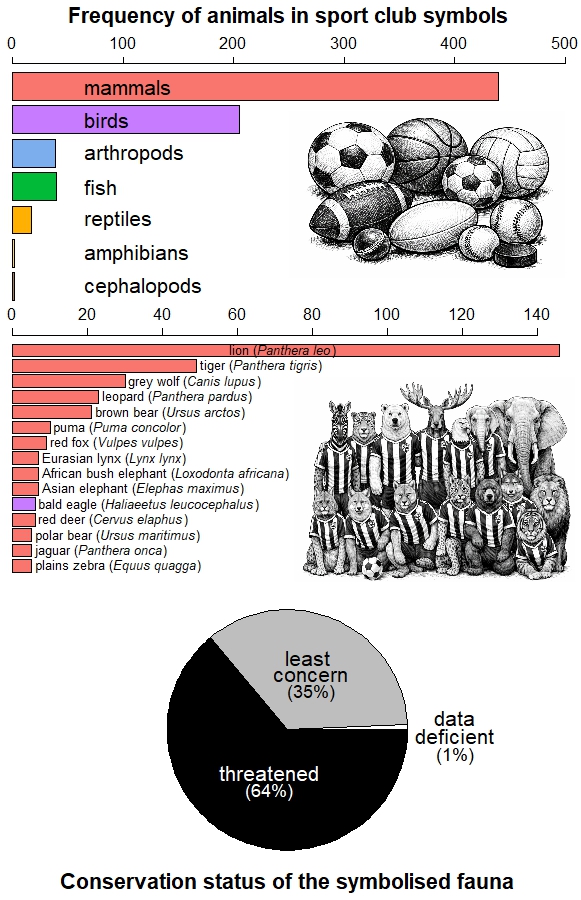
Using animals as sport symbols reflects the integration of biodiversity into cultural identity and the transmission of collective values. This raises the possibility that the economic muscle of the sport industry could translate its symbolic capital into tangible commitments to biodiversity conservation.
Those who have had the privilege of travelling in remote areas might have come across an unexpected scene: a football pitch in the middle of the Amazon rain forest or on the slopes of the Andes, a basketball court on the side of a Buddhist temple, or an ice hockey rink on a snow-ploughed lake in remote northern Canada.
Sport is a global industry that generates identity, belonging, education, and shared emotions for both athletes and their avid spectators (1). Sporting affinities now rival the sense of nationhood once shared by citizens during warfare (2).
Now in our heavily monetised world, sport clubs rely on their fans through tickets and merchandising, and indirectly through television rights and advertising. In this both emotional and commercial relationship, expressions such as being true to the badge reflect the central role of corporate symbols in building bonds between a club and its supporters (3).
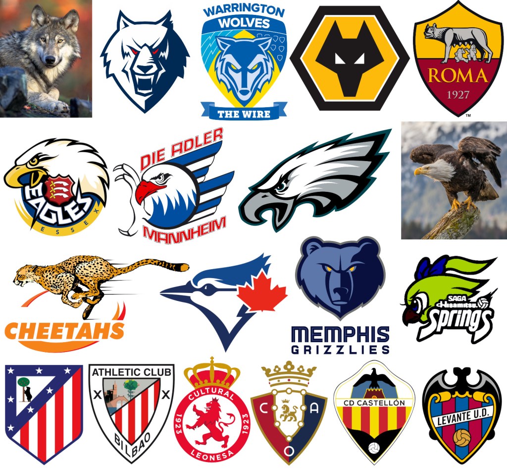
Sport club logos with animal iconography. Top row: examples of the grey wolf (Canis lupus) in Neftekhimik Nizhnekamsk (ice hockey, Russia), Warrington Wolves (rugby, England), Wolverhampton Wanderers (football, England), and Roma (football, Italy). Second row: bald eagle (Haliaeetus leucocephalus) in Essex Eagles (cricket, England), Adler Mannheim (handball, Germany), and Philadelphia Eagles (American football, USA). Third row: Free State Cheetahs (represented by the cheetah Acinonyx jubatus; rugby, South Africa), Toronto Blue Jays (blue jay Cyanocitta cristata; baseball, Canada), Memphis Grizzlies (grizzly bear Ursus arctos horribilis; basketball, USA) and Hisamitsu Springs (Japanese white-eye Zosterops japonicas; volleyball, Japan). Fourth row: six Spanish football clubs. Clubs featuring wolves and eagles are often associated with the symbolic qualities of these species (e.g., intelligence, prowess, fealty, bravery, strength). In football, animals reflect represent the history and heraldry of cities and regions, as seen in the crests of in Atlético de Madrid (brown bear Ursus arctos), AS Roma and Athletic Club (wolf), Cultural Deportiva Leonesa and Atlético Osasuna (lion Panthera leo), CD Castellón (raptor) and Levante UD (bat). Photos: Gary Kramer (wolf) and Andy Morffew (eagle).
In professional sport such as football, clubs increasingly function as brands (4) where even traditional logos are modified to enhance a team’s commercial value and strengthen audience loyalty (5). In this process, biodiversity becomes relevant because the iconography of many sport organisations incorporates representations of plants and animals.
Sport fauna
To quantify this phenomenon, Ugo Arbieu and collaborators analysed the presence of animals in club names, crests, and fan nicknames among 10 professional team sports across 50 countries (6). They found that 727 teams use 161 different animal species in their corporate imagery. Football and basketball lead in the number of species represented due to the large number of clubs worldwide, but American football, rugby and baseball display greater symbolic fauna diversity per club. Mammals and birds are the most common, particularly carnivores and raptors.
Animal symbols in club iconography (names, logos, fan nicknames) for the sports with the largest audiences (6): basketball, handball, baseball, cricket, football, American football, ice hockey and volleyball. The sample excludes 106 teams that use domesticated species as identity symbols, includes 163 men’s leagues and 67 women’s leagues, respectively, and the animal species depicted in the emblems of 48 teams could be identified. Horizontal bars above show the most represented animal groups (top panel), and the 15 species most frequently featured (middle panel). Bottom panel: percentage of symbols according to the IUCN’s conservation status of the species, where ‘threatened’ includes the categories Near Threatened, Endangered and Extinct. The trend indicates that sport clubs prefer to identify themselves with large mammal species that are threatened.
This pattern is not coincidental, for it reflects the historical bias of science and conservation towards large, charismatic vertebrates (7), but also the uneven availability of biological information and our social preferences for certain species (8). These preferences are even reflected in the animal emojis we share regularly on social media (9).
Arbieu’s study also revealed that clubs tend to favour images of threatened fauna (6), possibly due to their higher symbolic impact and media visibility (10). Moreover, although clubs in Europe and the Americas more often depict exotic animals, native species dominate in Africa, Asia, and Oceania (6). This suggests that the choice of an animal as an emblem is the product of not only aesthetic or symbolic criteria, but also of cultural roots and the historical relationship of societies with their local fauna.
Under the sea where there is little or no light, the foraging, communication, and orientation of whales and many other marine animals depend on sound. But increasing human activity has transformed the soundscape of seas and oceans. This change affects the behaviour of species and presents challenges in managing a problem of global scale.
Many like me feel uneasy when we hear a siren on the street. An ambulance, fire fighters, or the police can remind us of times when we or someone close to us suffered a heart attack, a fire, or a robbery. Animals can also associate sounds with risky situations they have experienced before, such as an attack from a predator, in their own lives or in the evolutionary history of their species.
For example, many types of whales are prey to killer whales (1) [watch predatory scenes here, here, here], and not only do they recognise the presence of their main predator by sound, but the vocalisations of some species have evolved to fall outside the killer whale’s hearing range (2). When faced with such a threatening sound, species must decide whether the risk of being hunted is great enough to justify interrupting essential activities such as feeding or mating (3). Interestingly, there are alarm signals that are so general in the animal kingdom, like a simple noise, that prey animals might react to them by spending time and energy to protect themselves, even when there is no real threat (4).
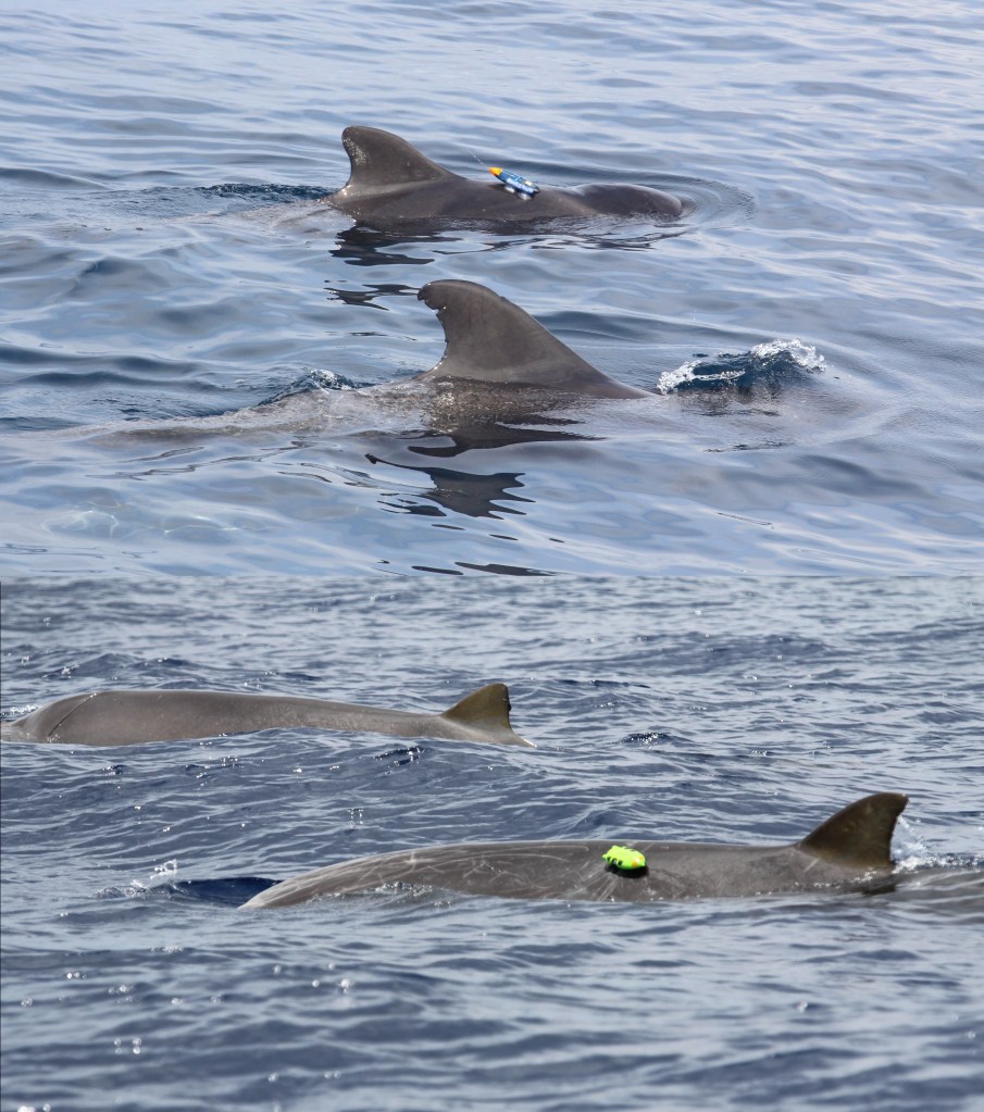
Tagging cetaceans off the Canary Islands to study their behaviour in relation to human and environmental disturbance. Above, 2 short-finned pilot whales (Globicephala macrorhynchus) in the southwest Tenerife, and below 2 Blainville’s beaked whales (Mesoplodon densirostris) in the Mar de las Calmas southwest of El Hierro. The back-mounted devices are DTAGs [read here, here and here]: they are attached by suction cups on top of which an encased electronic device records time series of environmental (depth, pressure, temperature, magnetic fields) and biological (e.g., swimming speed, heart rate, echolocation) variables. Watch videos of scientists deploying DTAGs on a range of cetacean species using a long stick here and here and drones here and here. Photos courtesy of O Marín Delgado (pilot whales) and C Yzoard (beaked whales); projects based at Universidad de La Laguna, Tenerife, Spain and led by N Aguilar de Soto [see stories here and here] (9, 26-29).
Naval sonar and killer whales
To examine this issue, Patrick Miller and his colleagues used underwater microphones to play recordings of killer whale sounds and ship sonar in the presence of 43 individuals from four cetacean species off the coasts of Norway and its Svalbard Archipelago (5): northern bottlenose whale (Hyperoodon ampullatus), humpback whale (Megaptera novaeangliae), long-finned pilot whale (Globicephala melas), and sperm whale (Physeter macrocephalus) [see press release for this research paper, listen to a podcast discussing findings]. During the experiment, each of the 43 individuals studied was fitted with a digital device attached to the skin using a suction cup. These devices recorded the animals’ movements and vocalisations. In total, the researchers collected 179 hours of baseline behaviour data in natural background noise, along with 7 hours of behavioural data in response to experimental playbacks of sonar [listen] and killer whale [listen] sounds.
Those of us living with cats share our homes with an ancestral predator, one adapted for hunting and the frequent, exclusive consumption of meat. These instincts become fully activated outside the domestic environment, where cats pose a global threat to wildlife.
Pets are family. We celebrate their arrival with the same joy as a grand homecoming, and their absence leaves a grief as deep as losing a loved one. In bonding with cats and dogs, we often attribute human abilities and emotions to them.
But beyond this affection, domestic animals still carry the instincts and genetic legacy of their wild ancestors(1, 2). My cats — Caruso, Muesli, and Plata — have been calm and loving, but they have always enjoyed a real hunt (3). When a moth comes in through a window, they seem possessed: their mouths chitter and make clicking sounds, they leap from one piece of furniture to another, and their heads snap sharply between the insect’s position and other points in the room, calculating the best spot from which to pounce on their prey. That is why when they become feral, cats and dogs integrate into food chains like any other species: they compete for ecosystem resources, hunt and are hunted, and hybridise and exchange diseases with other carnivores (4, 5).
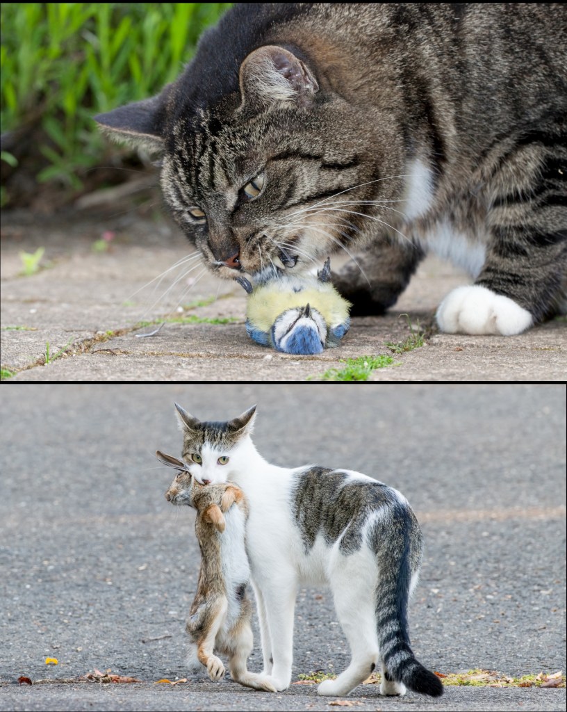
Top: cat eating an Eurasian blue tit (Cyanistes caeruleus), a common visitor to home gardens in Nijmegen (Netherlands). Bottom, domestic cat after hunting an Eastern cottontail rabbit (Sylvilagus floridanus) in a residential neighbourhood of Stratford (Connecticut, USA). Photos courtesy of Jelger Herder (Nijmegen) and Scott Kruitbosch (Stratford). Scott is a photographer and conservationist. Near sunset on 30/09/2020, while intently observing local wildlife, he witnessed a neighbourhood cat sneak up from behind on a cottontail feeding in open grass and grab it. For years, Scott has had extremely negative interactions, both in person and online, with local residents over these issues. These exchanges have revealed that many people show little concern for wildlife or for the dangers their outdoor cats face, and believe that their cats would not, or could not, harm wildlife.
Domestic cats are highly skilled hunters, and their predatory interactions with a wide range of prey are widely documented in social media and documentaries. Some examples include cats catching: bats and birds on the wing, butterflies, chipmunks, dragons, fishes, grasshoppers, frogs, lizards, mice, owls, rabbits, seagulls, snakes, squirrels, and wallabies. See an award-winning photo depicting wildlife with fatal injuries caused by cats recorded in 2019 at a single animal hospital in the USA, and a video showing domestic cats mimicking bird calls and some cat owners explaining that their pets reject commercial cat food after experiencing the thrill of hunting real prey. The documentary Secret Life of Cats contextualises the ecological challenges posed by free-roaming cats.
Many animals avoid contact with people. In protected areas of the African savanna, mammals flee more intensely upon hearing human conversations than when they hear lions or sounds associated with hunting. This fear of humans affects how species use and move in their habitat.
Throughout our lives, we interact with hundreds of wildlife species without stopping to think about it. These interactions can be direct, such as encountering wild animals while hiking in the mountains or driving through rural areas — or more deliberate, as when we engage with wildlife for food, sport, or trade. As hunters, fishers, and collectors, we kill more than 15,000 species of vertebrates — one-third of known diversity — a range of prey 300 times greater than that of any other predator our size (1).
Now, let’s look at it from the other side. Anyone who has survived an attack or a fatal accident, they understand that the experience is remembered for a lifetime. Likewise, animals store information about threatening or harmful encounters with humans (2). For them, adjusting their behaviour in response to human presence has implications for their survival and reproduction (3, 4), which are passed down from generation to generation (5). This ability to adapt, for example, determines which individuals, populations and species coexist with us in urbanised environments (6).
Response to dangerous sounds
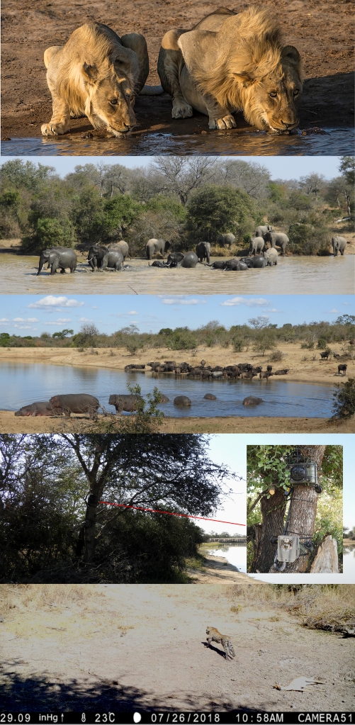
Liana Zanette and her team measured the flight responses of wild mammals in the Greater Kruger National Park (South Africa) when exposed to sounds that signal danger (7) [video-summary]. To do this, Zanette recorded videos of more than 4,000 visits to 21 waterholes by 18 mammal species. During each visit, a speaker attached to a tree randomly played one of five playback sounds: hunting dogs barking, gunshots, lion growls, human conversations in a calm tone and, as a control, the songs of harmless birds.
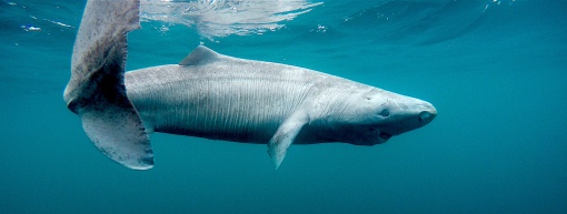
Deep-sea sharks include some of the longest-lived vertebrates known. The record holder is the Greenland shark, with a recently estimated maximum age of nearly 400 years. Their slow life cycle makes them vulnerable to fisheries.
In the Arctic, there are whales that have survived since the time of Napoleon’s Empire; in the Atlantic, there are molluscs that were contemporary with Christopher Columbus’ voyages; and in Antarctica, there are sponges born before the Holocene when humans were still an insignificant species of hunter-gatherers (see video on lifespan variation in wildlife).
Long-lived species grow slowly and reproduce at later ages (1, 2). As a result, these animals require a long time to form abundant populations and to recover from fishing-related mortality.
Among cartilaginous fish (chimaeras, rays, sharks, and skates), the risk of extinction due to overfishing is twice as high for deep-sea species compared to coastal species, because the former have longer and slower life cycles (3).
Procreating with a relative is taboo in most human societies for many reasons, but they all stem from avoiding one thing in particular — inbreeding increases the risk of genetic disorders that can seriously compromise a child’s health, life prospects, and survival.
While we all inherit potentially harmful mutations from our parents, the effects of these mutations are often partially or completed masked if we possess two alternative variants of a gene — one from each parent. However, the children of closely related parents are more likely to inherit the same copies of harmful mutations. This is known as ‘inbreeding depression’.
But inbreeding depression can happen in any species, with the risk increasing as populations become smaller. Because many species are rapidly declining in abundance and becoming isolated from one another predominantly due to habitat destruction, invasive species, and climate change, the chances of inbreeding are also increasing.
Not only are such populations more susceptible to random disturbances, they are also victim of reduced population growth rates arising from inbreeding depression. This produces what is generally known as the ‘extinction vortex‘ — the smaller your population, the more you inbreed and produce sub-optimal offspring, leading to even more population decline and eventually extinction.
One emergency intervention that can ‘rescue’ such inbred populations from extinction (at least in the short term) is to introduce unrelated individuals from other populations in an attempt to increase genetic diversity, and therefore, the rate of population growth. While somewhat controversial because some fear introducing diseases or eroding local-area specialisation (so-called ‘outbreeding depression’), the risk-benefit ratio of this ‘genetic rescue’ is now widely considered to be worth it.
I used to think it was merely a post-COVID19 hiccough, but the extensive delays in receiving reviews for submitted manuscripts that I am seeing near constantly now are the symptoms of a much larger problem. That problem is, in a nutshell, how awfully journals are treating both authors and reviewers these days.
I regularly hear stories from editors handling my papers, as well as accounts from colleagues, about the ridiculous number of review requests they send with no response. It isn’t uncommon to hear that editors ask more than 50 people for a review (yes, you read that correctly), to no avail. Even when the submitting authors provide a list of potential reviewers, it doesn’t seem to help.
The ensuing delays in time to publication are really starting to hurt people, and the most common victims are early career researchers needing to build up their publication track records to secure grants and jobs. And the underhanded, dickhead tactic to reset the submission clock by calling a ‘major review’ a ‘rejection with opportunity to resubmit’ doesn’t fucking fool anyone. The ‘average time from submission to publication’ claimed by most journals is a boldface lie because of their surreptitious manipulation of handling statistics.
The most obese pachyderm in the room is, of course, the extortionary prices (and it is nothing short of extortion) charged for publishing in most academic journals these days. For example, I had to spend more than AU$17,000.00 to publish a single open-access paper in Nature Geoscience last year. That was just for one paper. Never again.
Anyone with even a vestigial understanding of economics feels utterly exploited when asked to review a paper for nothing. As far as I am aware, there isn’t a reputable journal out there that pays for peer reviews. As a whole, academics are up-to-fucking-here with this arrangement, so it should come as no surprise that editors are struggling to find reviewers.
In boreal forests, many hares adopt white winter coats before the snow arrives. In a snowless landscape, these white hares lack camouflage against predators. However, their early moult from brown into white fur can increase their survival and offers an advantage as the snow season becomes progressively shorter with climate change.
Throughout the year, we wear different clothing to protect ourselves from the cold or heat and for aesthetic reasons depending on the occasion. Likewise, many animals change the colour, thickness and structure of their fur and feathers in tune with the seasons.
Snowshoe hare (Lepus americanus) in a snowy (Kluane Lake/Yukon, Canada) and snowless habitat (Seely Lake/Montana, USA). This mammal moults its coat as colder temperatures, shorter days, and snowfall arrive. In the genetic populations of the temperate forests of the Rocky Mountains and the boreal forests spanning the North American continent, hares that moult from brown to white are abundant (20). However, in coastal areas, and in the third genetic population in the North Pacific, snowfall is brief and less intense, resulting in fewer white individuals. This is due to hybridisation with the black-tailed jackrabbit (Lepus californicus) over 3,000 years ago (17). The hare’s coat has an outer layer, where the longer fur gives each individual its colour, and an inner layer of short fur (19). In winter, the outer layer becomes thicker and denser, while the inner layer maintains a consistent thickness but increases in density. By biomass, the snowshoe hare is the primary herbivore in the North American boreal forest and distinguishes the trophic relationships between continents (21). In Europe, much of the boreal understory remains under snow, providing food for rodents with four-year abundance cycles controlled by small generalist predators (mustelids). In North America, the boreal understory grows above the snow and provides food for hares. In this region, snowshoe hare populations follow 10-year abundance cycles regulated by specialist predators (those that feed almost exclusively on hares), primarily the Canada lynx (Lynx canadensis) (6). Photos courtesy of Alice Kenney and Charles Krebs (Yukon) [see their ecological monitoring program here] and Marketa Zimova (Montana).
However, as the climate changes, springs arrive earlier, winters are delayed, and the frequency and intensity of precipitation have become highly variable. All of this makes it harder for species to adjust their wardrobe to temperature changes (1).
In this context, body colour is a critical factor for birds and mammals that undergo an annual moult (2). In 21 species from the cold latitudes of the Northern Hemisphere, some individuals are brown in summer, but turn white in winter, while others remain brown year round (3). This phenomenon includes weasels, rodents, ptarmigans, foxes, rabbits and hares.
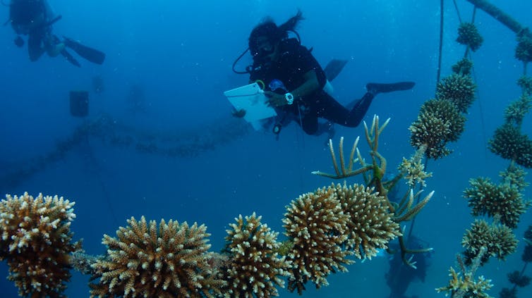
Coral reefs are much more than just a pretty place to visit. They are among the world’s richest ecosystems, hosting about a third of all marine species.
These reefs also directly benefit more than a billion people, providing livelihoods and food security, as well as protection from storms and coastal erosion.
Without coral reefs, the world would be a much poorer place. So when corals die or become damaged, many people try to restore them. But the enormity of the task is growing as the climate keeps warming.
In our new research, we examined the full extent of existing coral restoration projects worldwide. We looked at what drives their success or failure, and how much it would actually cost to restore what’s already been lost. Restoring the reefs we’ve already lost around the world could cost up to A$26 trillion.
Bleached Acropora corals in the Maldives.Davide Seveso/University of Milan
When sea temperatures climb above the seasonal average for sustained periods, corals can become bleached. They lose colour as they expel their symbiotic algae when stressed, revealing the white skeleton underneath. Severe bleaching can kill coral.
Night is the peak activity period for many animal species. In the Western Andes of Ecuador, the Chocó golden scarab flies between forest patches during the night, but urban lighting interferes with their paths and jeopardises populations already struggling to persist in fragmented native forests.
Urban development has created a network of illuminated infrastructure that allows our society to function day and night without interruption. It is no surprise that with so much artificial light, we increasingly have to move farther away from towns and cities to see a sky full of stars.
Light pollution poses a challenge for nocturnal species that have adapted to living in the dimness of night (1, 2) — see documentaries about the impacts of artificial light on wildlife and insects, and a related scientific talk. This problem might be one of the causes of the global decline in insects (3, 4), in turn negatively affecting their role in maintaining agricultural systems through pest control, pollination, and soil quality (5). These concepts are featured by the documentaries The Insect Apocalypse and The Great Death of Insects.
Chocó golden scarab (Chrysina argenteola) walking on forest litter in La Maná (Cotopaxi, Ecuador). Growing to up to 4 cm in length, this species inhabits the tropical rainforest of the Chocó region in the Western Andes (10), where it is frequently attracted to artificial lights at night. The striking colour of this ‘jewel scarab’ is an optical illusion. The exoskeleton is covered with overlapping layers of chitin that polarise light and reflect hues of blue, gold, green, silver, or reddish tones, depending on the species (16). The metallic sheen appears to deter bird predation (17) and might serve as camouflage as well as aid in individual recognition (11). The eyes of insects are ‘compound’ — composed of 100s to 1000s of tubular eyelets (‘ommatidia’), each with its own cornea and lens (18), and all collectively contributing to insect vision. In nocturnal species like the golden scarab, the photoreceptor cells (at the base of each ommatidium) respond more slowly to light compared to diurnal species, allowing the former to collect more nocturnal light per unit of time before forming an image (19). However, just as staring at the sun blinds us, eyes adapted for night vision become overwhelmed by excessive artificial light, disrupting the behaviour of these species. Below the scarab image are two photographs contrasting the day and night landscapes of the same location in Pedro Vicente Maldonado (Pichincha, Ecuador) within the species’ distribution range. Photos courtesy of Martín Bustamante (animal) and Luis Camacho (city).
When flying, nocturnal insects orient their backs toward the sky, using the light of the moon and stars as a reference (6) (explained here and here). However, when they encounter artificial lights, they can no longer distinguish up from down, and so they can become disoriented, flying erratically, like a moth circling a streetlight.
It is estimated that a third of the insects attracted to artificial light die from collisions, burn injuries, exhaustion, and/or predation (7). In the tropics, finding countless dead insects at the base of urban lights is a common scene. Equally important is that artificial light also hinders migration, foraging, and the search for mates in many nocturnal species (1, 8, 9).
Nocturnal jewels
Camacho and collaborators evaluated the effect of artificial lighting at night on the Chocó golden scarab (Chrysina argenteola) (10). This species inhabits the tropical rainforests of the Western Andes from Ecuador to Colombia, and is a member of the group known as ‘jewel scarabs‘ due to their metallic body coloration (11). Because of its nocturnal habits and the larvae’s dependence on wood for food (12), the golden scarab has been increasingly affected by the loss of native forest in combination with light pollution from rural and urban expansion.
Yes, it’s bad, especially for US-based scientists. It also affects scientists in Australia and the rest of the world. But there are ways to get around the problem. There might even be a silver lining to this dark cloud.
Trump cannot stop global climate action, although he might slow it. Nor can he hide the truth by restricting access to data. Climate research will continue despite Trump’s best efforts to hamstring scientists and research institutions.
No strength in ignorance
Last year was the warmest on record, a fact that yet again confirms our worst-case predictions. The world has already surpassed the (arbitrary) 1.5°C threshold increase relative to pre-industrial temperatures — a threshold that only a few years ago we didn’t think we would cross until 2030 at the earliest.
We’re now on track to be living in a world that’s 3°C hotter or more by the end of the century.
But ignoring climate change won’t make it go away. Like the Ministry of Truth in George Orwell’s classic dystopian novel, 1984, Trump seems to believe “ignorance is strength”. He’s trying to erase facts about the climate crisis, perhaps to keep people ignorant and subdued.
What this means for Australian climate science
Many Australian scientists (including me) collaborate regularly with US colleagues, share funding, and publish results together. Knowledge sharing and open-access data are the foundation of advances in science, so Trump’s assault will inevitably slow progress here.
For example, Australian and US scientists regularly collaborate in big-ticket research and policy development related to climate change, such as the Intergovernmental Panel on Climate Change’s Physical Science Basis reports. But even with fewer US scientists in the mix, the research and reporting will continue.
Other reputable climate-data repositories around the world include the European Union’s Climate Data Store, the University of East Anglia’s Climate Research Unit, the Netherlands Meteorological Institute’s Climate Explorer, and the independent WorldClim, to name a few.
While restricting access to US-based websites is inconvenient, we can readily get around the problem. Many of my colleagues have also been downloading data prior to the purge mandate to maintain access.
Consequences for the US
Over the past month I have been inundated with horror stories from many US-based colleagues in academia and the public service, who have lost their jobs and/or research funding. In addition to these very real personal tragedies, the bigger picture is even bleaker.
The loss of scientific and technical expertise these mass sackings entail weakens the capability of the US workforce to discover and develop solutions to climate change. Just when we need good scientific and engineering innovations more than ever, a massive capacity is being erased before our eyes.
More emissions mean more climate change, especially when you’re already one of the biggest contributors to the global problem. The US is the second-highest greenhouse emitter in the world, behind only China.
On his first day as president, Trump withdrew the US from the Paris climate agreement. This effectively removes his country from all binding limits on actions that contribute to climate change.
Weakening international treaties is a two-edged sword, because it not only lets the US off the leash, it also potentially discourages other nations from acting responsibly. Analogous to the “unresponsive bystander effect”, many nations may now be more hesitant to commit to reductions because one of the biggest emitters refuses to do anything about it.
Trump has also slashed US international aid, which will slow climate action in countries that need the most assistance.
Overall, faster rates of warming will inevitably put more strain on natural resources and agricultural production. This could increase the probability of international warfare over water, food and other essential natural resources. Because autocratic countries cope worse with food shortages than democratic ones, climate emergencies will penalise nations led by despots more heavily.
Trump’s foolhardy anti-climate campaign is enough to make many people despair. But there are a few faint glimmers of hope on the horizon.
As the US shirks its domestic and international responsibilities, other countries might resolve to do more. Not relying on the US could force capacity-building elsewhere. Some even suggest without the US at the table slowing progress, stronger climate action might result.
Americans have their own daunting fight on their hands. But the rest of the world will have to take up the slack if we have any chance of limiting the health, wealth, equality, human rights and biodiversity calamities now unfolding because of climate change.
Corey J. A. Bradshaw, Matthew Flinders Professor of Global Ecology and Node Leader in the ARC Centre of Excellence for Indigenous and Environmental Histories and Futures, Flinders University
This is a fixed-term position for up to 3 years, and we are especially targeting Indigenous candidates.
The successful candidate will use existing code and develop new approaches to analyse complex data derived from lake, lagoon, river, and wetland cores measuring various aspects of dated vegetation composition, fire regime, and climate fluctuation. Additionally, the successful candidate will design simulation models to evaluate how different proxies behave under various environmental conditions, aiding in the interpretation of outputs from time-series models.
As a position under CIEHF, the position requires co-designing projects with Indigenous Partner Organisations, as well as extensive travel to the other Nodes within CIEHF to collaborate with palaeo-ecologists, climatologists, archaeologists, and other relevant specialists.
For more information and details on the application process, visit this link.
The internet has become an informational telescope to study what happens nearly everywhere the planet. Using internet observations, it has been recently documented that terrestrial hermit crabs use plastic waste as shelter along tropical coasts.
Before the internet irrupted, I was living in Spain and frequently travelled from my hometown to universities in Valencia and Barcelona to access scientific journals. Back then, these journals were only available in print or on compact discs. Today, I can do the same thing from home with an internet connection.
The emergence of public internet since the 1990s has globalised information and represents a data source for many areas of science (1, 2). When applied to nature, the term iEcology (internet Ecology) refers to the use of online documentation to study the natural history of plants and animals, their distributions, and the effects of humans on them (3). In fact, the internet highlights and promotes certain research topics. For example, bird species that are more frequently mentioned on social networks tend to be described taxonomically earlier, and are also the ones that interact most (positively or negatively) with human activity (4).
In search of the phenomenon
By exploring internet platforms Alamy, Flickr, Google, YouTube, and iNaturalist, Zuzanna Jagiello and her collaborators collected nearly 30 thousand photographs of hermit crabs to study the use of rubbish by these crustaceans (5). Hermit crabs are known for their peculiar habit of using empty snail shells to house their unprotected abdomens, carrying them around like someone travelling with their house on their back (6) — David Attenborough narrates here a funny swapping of shells among crabs of different size. The researchers aimed to assess the extent of the phenomenon of hermit crabs replacing natural shells with artificial materials as mobile homes (see video capturing the scene).
If you’re like me, you use a lot of loops in R. I do not profess to be the most efficient coder, but loops make sense to me and I’m generally not concerned about make the fastest simulations.
But sometimes my loops take some time to finish, so I often add a rolling text update during the simulation to know how far it has progressed. But of course, I have to look at the R console to see how far things have come. Being a bit away from the central tendency of the spectrum, I can get absorbed in doing other things, so I often miss when the simulation is complete.
In a fit of excess geekiness, I’ve recently discovered voice prompts in MacOS that I can now code directly into my R simulations to give verbal updates on their progress. I find these immensely useful. I’ve therefore decided to share the basic code, because I know some other geeks out there might also appreciate the tool. Apologies — I haven’t investigated how to do this in a PC environment, so the following examples are MacOS-specific.
First, go to your Accessibility settings in System Settings in your Mac. Click on System Voice to see what voices you have access to, and which voices you wish to download to your machine. There are many languages supported.
When you construct a loop in R, add the following code within and before the loop content (this example is in English):
iter <- 1000 # number of iterations
itdiv <- iter/100 # iteration divisor 1
itdiv2 <- iter/10 # iteration divisor 2
st.time <- Sys.time() # time at start of simulation

# loop from 1 to iter
for (i in 1:iter) {

    # pause execution for 0.05 seconds (this would normally be the guts of your loop functions)
    Sys.sleep(0.05)

    # loop updaters with voice (English)
    if (i %% itdiv==0) print(paste("iter = ", i, sep=""))

    if (i %% itdiv2==0 & i < iter) system2("say", c("-v", "Fiona", paste(round(100*(i/iter), 0),
                                            "per cent complete"))) # updates every 10% complete
    if (i == 0.95*iter) system2("say", c("-v", "Fiona", paste(round(100*(i/iter), 0),
                                 "per cent complete"))) # announce at 95% complete
    if (i == 0.99*iter) system2("say", c("-v", "Fiona", paste(round(100*(i/iter), 0),
                                 "per cent complete"))) # announce at 99% complete

    if (i == iter) system2("say", c("-v", "Lee", "simulation complete"))
    if (i == iter) system2("say", c("-v", "Lee", paste(round(as.numeric(Sys.time() - st.time,
                            units = "mins"), 2), "minutes elapsed")))
}
Here I’ve used the female Scottish voice ‘Fiona’ and the male Australian voice ‘Lee’.
Quite a bit late this year, but I’ve finally put together the 2023 conservation / ecology / sustainability journal ranks based on my (published) journal-ranking method (as I’ve done every year since 2008).
After 16 years of doing this exercise, I can’t help but notice that most journals don’t do much differently from year to year. They mostly tend to publish the same number of papers, get the same number of total publications, and therefore, remain approximately in the same rank relative to others.
Some things to note: Clarivate continues to modify its algorithm, meaning that most journal Impact Factors have gone down yet again. This is somewhat irrelevant from the perspective of relative ranking, but it might piss off a few journals.
I therefore present the new 2023 ranks for: (i) 111 ecology, conservation and multidisciplinary journals, (ii) 29 open-access (i.e., you have to pay) journals from the previous category, (iii) 68 ‘ecology’ journals, (iv) 33 ‘conservation’ journals, (v) 44 ‘sustainability’ journals (with general and energy-focussed journals included), and (vi) 21 ‘marine & freshwater’ journals.
Get Conservation Bytes by Email Enter your email address to receive new posts on conservation, biodiversity, and environmental science directly in your inbox. No need to visit the website regularly, and you can unsubscribe at any time.
Hulton Archive / Getty Images We warn readers that the content of this study is confronting and may be distressing. In April 1789, the first smallpox epidemic among Aboriginal people in the Sydney region began, just 16 months after Europeans arrived on the First Fleet. Little is known of the true scale of the epidemic,…
Just over two years ago I reported the ‘likely’ eradication of feral pigs from Australia’s third-largest (4,405 km2) island — Kangaroo Island. I indicated ‘likely’ because the program still required the proof-of-eradication phase to be completed before an official declaration could be made. Yesterday I had the immense honour to take part in the official…
Have you ever done any research that relied to any degree on Indigenous Knowledges? How did you cite those Knowledges, if at all? It’s probably time we rethink how we engage with Indigenous Knowledge systems. In a new article published in BioScience, we — a large group of Indigenous and non-Indigenous scholars in Australia —…